I can't wipe the silly grin off my face. What a great day! It was raining. The wind meter readings were at 20 mph for about 20 minutes, and that was after I had left the water. I crashed a lot. My top speed was 17.3 knots, and my distance sailed 14.6 km - both numbers that usually would indicate a terrible day.
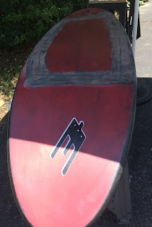
But I was on the foil. I had spend about 8 hours repairing my 71 cm slalom board that had a large-scale delamination on the bottom. Here's a picture of the zombie board in its current state:
Well, the little zombie works a lot better than old Skate 110 or Nina's Bic Nova 170 I've tried before, so I've been foiling every time I got a chance in the last week, even when we got enough wind to plane on regular gear. Here are today's tracks:
It was low tide, so I stuck with the 60 cm mast, which probably limited my upwind angles (at least that's my excuse :-). I spent a lot of time pinching upwind, but I was just barely powered most of the time. That limited the number of jibe attempts to less than a handful, but even in several of these attempts, I was amazed how long the board stayed on the foil and out of the water. Here's a video of one of the attempts:
I was so surprised to still be foiling that I just held on to the mast and waited for things to drop down...
I'm not sure what it is about foiling - the silent flying? The gently touches? The 100% concentration that forces you "into the zone"? The fun of learning something new, and be scared by going about half as fast as when windsurfing? Whatever it is, I love it! So big thanks to Andy Brandt and the ABK Boardsports crew for giving me lots of opportunities to try foiling; Slingshot for sponsoring ABK; and Britt Viehman from North Beach Windsurfing for advice and hooking us up with a great foil.
Tuesday, June 25, 2019
Monday, June 24, 2019
GPS Tracks in Google Earth
One of the features in GPS Speedreader I like is the ability to export GPS tracks to Google Earth to create pretty "crayon artwork", as Fangy call the images. Here's an example:
There are a few options to customize what you see:
For example, you can set a minimum speed, so that parts where you were going slow are all shown in the same color. A variety of different color schemes are also available. Here's the "high contrast" colors for the same track:
For the lower graph, I had selected the "Include time stamps and speeds" checkbox in the export options. This enables the time line in Google Earth, so you can "play" your tracks. It also write the doppler speed data to the exported file, which you can see as a graph at the bottom of the image (to see the graph, you have to right-click on the "Speed graphs" item in the side bar, and select "Show elevation profile"; then you'll have to click on the "Doppler speeds" in the graph panel). The speed graph also reacts to moving the mouse over it by showing an arrow with the speeds in the image above. You can also select regions in the graph to get average speeds for the region. Go ahead and play with it - downloads are free at https://ecwindfest.org/GPS/GPSSpeedreader.html.
Another new feature in the just-released version 1.2.8 is support for .sbn files from Locosys GT-31 GPS devices.
There are a few options to customize what you see:
For example, you can set a minimum speed, so that parts where you were going slow are all shown in the same color. A variety of different color schemes are also available. Here's the "high contrast" colors for the same track:
Another new feature in the just-released version 1.2.8 is support for .sbn files from Locosys GT-31 GPS devices.
Wednesday, June 19, 2019
That's Why We Use Freestyle Sails
This is why we use freestyle sails:
With freeride sails, the arms are too short for duck jibes! My large freestyle sails needs to be replaced (or have 5 (!) panels repaired), so I used a 6.0 freeride sail. I did move my hand back before the jibe, and my hands did crossover to get closer to the end of the boom:
Pictures by Eddie Devereaux (thanks!).


