
The usual SE playground is West Dennis (marked with an "A") in the map. But besides the $20 fee and a drive that seems to take forever during tourist season, the birds have taken over - the usual windsurf spot is blocked off.
Next to Monomoy Island (marked with a "B") on the map might also be a great spot to find some flat and shallow water. But you'd definitely also find a lot of seals, and the occasional Great White Shark. And someone who does not want to drive to West Dennis now certainly would not want to drive twice as far!
So it was time to check out a closer spot: Oregon Beach in Cotuit. I had tried to sail there a few times before, but the wind never cooperated. But let me zoom in a bit to show you why I had not given up on it yet:

We started windsurfing shortly past low tide. As usual, Nina was on freestyle gear (90/4.7), so I also chose my Skate 110 and a 5.6 m freestyle sail. It was surprisingly bumpy in front, but after the first 30 minutes, the wind filled in nicely. I had fun doing mile-long runs over to Dead Neck. But when I checked with Nina, she said she did not like it much - the chop was a bit disorderly, the wind a bit gusty close to shore where she wanted to practice freestyle, and she even had found a few deep spots where she could not touch ground.
So now I had a perfect reason to check out Popponesset Bay! The sandbar in front would reduce the chop, and the inside should be shallow enough to stand - so off I went. Getting there from Oregon Beach (where you need a Barnstable resident sticker for parking during the season) was easy, and the bay was shallow, chop-free, and windy! I turned around to tell Nina, but discovered that she had followed me, and was waiting on the ocean side beach near the tip of the island.
We spent the next hour sailing inside Popponesset Bay - here are today's GPS tracks:
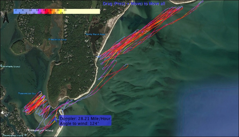

We sailed back when it started raining. Overall, the spot was not quite as good as I had hoped for, but it was still plenty of fun. There's definite speed potential inside the bay, ideally during ESE and within 2 hours of high tide. However, runs are a bit on the short side, and getting there on a really windy day would require braving some not-so-small chop on speed gear. On summer weekends, boat traffic might also be an issue, but today, we only saw two or three boats coming into the bay. Now if someone could just turn off the rain that usually accompanies easterly winds...