Sunday, February 25, 2018

BIB and Grassy Point Pictures

The last few times we sailed in Corpus Christi, Many Miles Mike and his wife Julie took some nice pictures. The originals are at www.gulfbreezewindsurfing.com/jamin-at-bib and www.gulfbreezewindsurfing.com/bluff-s-landing, but I took the liberty to copy a few shots:
Nina at Bird Island Basin


Speed at Grassy Point
Plenty of space for kiters and windsurfers
Needs more practice..

There was plenty of wind here the last couple of days, but we were in South Padre Island. After two great days there a few weeks ago in northerly winds, we figured we'd check it out in southerlies. It was plenty windy - Nina rigged down from 4.5 to 4.0, and still was a bit overpowered. But the tide was higher, and the wind was quite unsteady, which made it more similar to a typical day at BIB. Grassy Point in Corpus Christi seemed smoother on the one very windy day that we sailed there, which would be no surprise, given that the water is about a foot less deep there, and some spoil islands flatten the water even more. Looks like we'll get a a session or two there towards the middle of the week :-).

Monday, February 19, 2018

Naughty at Grassy Point

Sometimes, we are stupid. This is the fourth time we spend the winter in Corpus Christi. No, that's not stupid. What is somewhat stupid is that up until today, we have only sailed at Bird Island Basin. Don't get me wrong - BIB is a great spot for windsurfing, especially in typical ESE winds and NE wind, and it's a fantastic speed spot in NW wind (which we did not get at all this year). But in SSE wind, it's choppy - bum-bum-bum chop when going out, with "catch the back of the chop" going back, plenty of cross chop, and not flat spots. Fine for freestyle, but limited fun on slalom gear.

I was in the mood for freestyle sailing yesterday, but discovered that my Skate 110 needs another repair - this time right in front of the back foot straps. So I bumped around on slalom gear, unable to get 30 knots despite good wind and trying hard. But fortunately, Many Miles Mike had suggested to try another spot today: Bluff's Landing, also called "Grassy Point".

We went at noon, and Mike explained us the local hazards (a few shallow spots and areas). The wind was around 25 knots, but the water looked quite flat. Being cautious, I went out on my 3S 96 and North Ice 4.7 to explore. What a different to BIB! The water was knee to hip deep, the chop maybe a foot high - not much difference to BIB, except that the shallow areas extended a lot further ... for miles. The fetch is a lot longer, so the wind is steadier, and the chop is nice and orderly.  I lasted about 15 minutes before I just had to go in and get my speed gear: the Isonic W54 (72 l) and the Loft Racing Blade 5.6. I also put on my Android phone so that I could hear GPSLogit announce the speed.

The first run out was fun - plenty of 26 and 28 knot announcements even though I was angling slightly upwind most of the time. The run back was crazy - 30 knot announcements most of the time, and tons of fun threading a path through the little waves. I right away knew I had improved my personal best (PB) for the nautical mile on the first run in!

I went back out. The second run out felt even better, probably because I had moved the mast foot forward to get a bit more weight on the front foot. Two kilometers out, I saw Nina, and stopped for a little chat. Nina pointed out that the long batten in my sail looked wrong - it was broken. Bummer!! I sailed back in, and despite a 2 knot lower top speed, I still was more than a knot faster over the nautical mile (which the Aussies call "naughty") than ever before. But then I de-rigged the race sail, and switched back to the freeride gear. Not as fast, but nice and relaxing! Fun, fun, fun.

We stopped by at Lazy Beach Brewing on our way home for a beer, and then some food (and more beer) at the Padre Island Burger Company. Finally home, my GPS software confirmed what GPSLogit had said: I had improved my PB for the naughty by almost two knots. Nice! Here are today's GPS tracks:
My runs were about 2 km long, but there's lots of room for longer runs:
Runs to the right of the spoil islands to the bridge would be about 5 km long - all of that in knee-to-hip deep water. Some areas between the spoil islands near the end of my tracks are too shallow, but some other areas deserve exploring.. I see some mud walk in my future.

This place has speed potential! But perhaps the biggest potential is later in the season, when it lives up to it's name: "Grassy Point". In the summer, the water level drops, and lots of see grass grows, to the point where some locals deem it unsailable towards fall. But reading what the Australians think about see grass at spots like Lake George and Liptons/Point Grey/Fangyland, that may just be the perfect recipe for wicked flat water and really fast speeds. Almost makes me want to come back in the summer .. just almost, though. But even now, with very little sea grass, I'd call this spot one of the best spots I have ever sailed. Big thanks to Many Miles Mike for making us check it out!


Tuesday, February 13, 2018

The Disappointment

No, I'm not bitching about the weather in Texas. Sure, it was near freezing yesterday, and about 15ºF colder than on Cape Cod .. but on a couple of days, we'll have 70 degrees here, and Cape Cod will be cold.

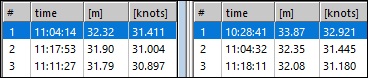
This is another GPS post. One about some major frustration - it took me 10 days to get ready to write about hit. This is about the results from a windsurfing test, comparing the USB GPS dongle to the GW-60. Here are the first numbers I looked at (from GPSResults):
The numbers are for 2 seconds, with GW-60 on the left and the dongle on the right. The dongle was 1.45 knots higher than the GW-60 .. very suspicious! A quick look at the tracks showed that the dongle was clearly wrong:
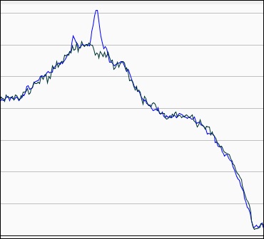
The dongle track is blue, the GW-60 dark green. The dongle has a clear artifact peak at the "top speed" region that is about 5 knots too high!

It did not end there. When I compared the results for the nautical mile, things also looked bad:
Again, the dongle gave substantially higher numbers - about 0.9 knots for the nautical mile!

Why did I suddenly get such bad results, after all my driving tests had indicated that the USB dongle would likely be more accurate than the GW-60?

The first hint came from the tracks that GPSLogit had recorded for the phone GPS. For several runs, the phone GPS tracks (in red below) also showed large artifacts:
The phone had slipped on my armband several times during the session; with the phone and USB dongle pointing down instead of up, and my upper arm and body blocking the GPS signal, the data quality suffered .. a lot. I verified this in the next two sessions, as I reported in my two previous posts. With the phone properly fixed so that it could not slide down, I got much more accurate, artifact-free results in two sessions.

I finally went back and gave the "bad" data a closer lock. The nautical mile results looked suspicious, so I looked at the numbers in GPS Action Replay. First the GW-60:
Next the USB dongle:
Finally, the phone:
All the numbers are very close - within 0.1 knots of each other, and within 0.03 knots between the GW-60 and the USB dongle! An examination of the data showed that, once again, missing data points and GPSResult's approach to "filtering" were the cause. At the beginning of the fastest nautical mile run, the GW-60 skipped quite a number of data points; instead of recording a point every 0.2 seconds, it recorded at irregular intervals for about 50 seconds: mostly one point every second, but also at 0.6, 0.8 second, and 3 second intervals. Here's a screen shot of the track point table from the start of the nautical mile run:
Since GPSResults will generally ignore sections with missing data points, it picked a slower section of the track as the "fastest" nautical mile. So this time, the observed differences in the nautical mile results were due to (a) the GW-60 missing data points, and (b) GPSResults not using this section. The effect was that the top speed for the nautical mile was understated by 0.9 knots because the GW-60 dropped points. The GPS dongle and the phone both gave the more accurate results!

This was quite different to the 2-second results, which are much more prone to distortions from artifacts (this is even more so for the "top speed", which is very often too high by 0.5-1 knots!). Here's a look at the data from the USB dongle in this region:
Note that eight of the ten points have error estimates above 1 knot, and 5 points have error estimates above 1.2 knots. Almost a year ago, when I looked at artifacts in GW-60 tracks, I had come to the conclusion that 2 second results with an average SDoP above 1.4 should not be considered for GW-60 data, since they are quite likely to be highly inaccurate. It is safe to assume that the u-blox GPS chip inside the USB dongle calculates the "+/-" numbers a bit differently than the GPS chip inside the GW-60; it appears that a slightly lower threshold may be necessary. When applying a SDoP filter with a 1.2 knot threshold in GPSResults to the dongle data from this session, the artifact peak is filtered out, and the top speed numbers for the dongle are very close to the GW-60 numbers.

One problem with accuracy filtering is that GPS Action Replay currently does not support it; another issue is that it can easily be turned off in GPSResults. However, there is a simple solution for the USB dongle recording software: it could simply set apply the filter before saving the data to a file, for example by setting the speed in the affected region to 0. The app could then also alert the user about the issue with a message on the screen and audio feedback, which could serve as a little reminder to check if the phone and dongle are positioned correctly. I'll look into this, but first I plan to collect more data with the USB dongle while windsurfing, to see if such a filter would possibly through out "good" data.

Friday, February 9, 2018

More GPS Comparison Data

Below are more results from comparing three GPS devices: the Locosys GW-60 watch, an Android phone (Moto E4) with GPS Logit, and the USB GPS dongle I had been testing. These results are from a Kona One session 2 days ago, as reported by GPSResults:
No surprise for the 2 and 10 second results. All differences for the phone are well within the +/- ranges for the watch, with maximum differences of 0.2 knots for 2 seconds, and 0.09 knots for 10 seconds. Numbers for the phone GPS are similar, but slightly higher. Note that for this session, the GW-60 watch and the GPSLogit data were recorded at 1 Hz, while the USB dongle recorded at 5 Hz.

The results for 500 m are similar, except that the phone GPS now does as well as the dongle. For the nautical mile, the results reported by GPSResults differ a lot for the phone. This is because GPSResults filtered out single data points in the middle of a few one-mile runs:
The sixth point is shown in brackets, meaning GPSResults filtered it. Since the GPSLogit data do not have accuracy estimates, and both acceleration and HDoP around this point is low, we have to assume that GPSResults considers data from 7 GPS satellites as insufficient (unfortunately, the Mac version of GPSResults does not show a setting for minimum number of satellites). Unchecking the "On" checkbox for all filters leads to results that are more similar to the watch and dongle:
However, the last 3 nautical mile runs for the phone show larger differences even without filters. This, however, appears to be an artifact of the analysis: the entire session was only about 20 nautical miles long, with just 12.9 nautical miles at speeds above 12 knots. Looking at the sections in GPS Action Replay shows that the speeds over the aligned nautical mile regions only differ by 0.01-0.05 knots; the reported larger changes are caused by slightly different regions being picked for the different units by the analysis programs. For the GPSLogit tracks, GPSResults was able to "squeeze in" a extra nautical mile run of 13.49 knots, while the same region between previously picked (higher speed) nautical miles was just a tad shorter than 1 nautical mile in the data from the two other devices. For speedsurfing competitions, this kind of artificial difference is entirely irrelevant; it only shows that some care has to be taken when analyzing the data.